Fentonville, Liberty Township, Jackson Co., Michigan
By Bill Leutz
A couple of weeks ago, this website posted a copy of a map of Columbia Township made available by Ted Ligibel, author of “Clark Lake: Images of a Michigan Tradition.” If you don’t have a copy of this great book about our lake, you can find one at the Beach Bar or Doyle’s on Hyde Road. Ted’s map is very interesting, as it is the oldest currently known of this area. Drawn by State Geologist, Charles Houghton, in 1844, it shows some features that were immediately unfamiliar.
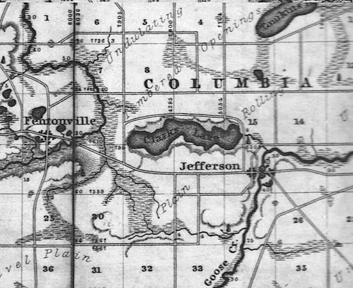
One of these was the existence of the town of Fentonville, in Liberty Township. Situated about 1½ miles west of Hyde Road, it appears on this map to lie at the corner of Gates Road and Jefferson Highway, ½ mile into Liberty Township. Being curious, as I am, I decided to look into this apparent ghost town. Much to my surprise, there was very little to find. After researching both of the published Jackson County Histories, and spending an hour or two at the Jackson District Library, I have discovered only one other reference to the village of Fentonville in Jackson County. It does not appear on maps of 1855 or 1878.
It seems that in 1839, an individual named Leonard Watters opened a general store in Liberty Township. The only clue we currently have as to where Watters built his store is found in The Interstate Publishing Companies 1881 version of The History of Jackson County. On Page 937, it is stated that Mr. Watters built his store in Fentonville.
It was the very first store in Liberty Township. Surprisingly, he did not build near the location of the sawmill that had been built two years earlier in the SW corner of Section 23, along the Grand River. In 1845, a flourmill (gristmill) was built on the opposite side of the river, in the NW corner of Section 26. Not surprisingly, this location then became known as Liberty Mills, the village we know as Liberty today. Liberty is the only village that has been shown on any map of Liberty Township I have found, other than that 1844 map of Houghton’s.
One can understand Mr. Watters desire to give his location a name to attract customers that had a little more zip than simply saying “Watters’ Store.” He may have wanted to speculate in land enough to actually build a town site away from the mosquito-infested swamp land that bordered the Grand River for most of it’s early course. Not having access to his diary, we can only speculate. The site he chose is on a modest rise, about ¼ mile north of the Grand River crossing of Gates Road. This general area was attractive enough that, some 40 odd years later, it was occupied by the East Liberty Unitarian Church’s Schoolhouse, as is shown on plat maps of that era.
Some confusion enters in to the story due to the historic existence of another village called Fentonville, in Genesee County, Mich. This one was originally named Dibbleville, but was platted in 1837 by William M. Fenton as Fentonville. He is better known for serving on the Michigan Senate from 1846-1847, and as the seventh Lieutenant Governor of Michigan from 1848-1852. This village changed its name to Fenton when it was incorporated in 1886, and is so known today. Thus both Fentonvilles have faded into the small print in history books.
So then what happened to Liberty Township’s Fentonville? Perhaps, discovering that there was already a Fentonville, Michigan, Watters dropped the name. Perhaps, he found there was too much competition; with Liberty Mills, only 1 ½ miles away, and rapidly-growing Jefferson City, at the other end of Clark’s Lake some 3 ½ miles away. Perhaps he sold out, or died, and the name of his proposed town died with him. We may never know.
But for the next curious reader, this map also provides other questions. First, the source of the current name of Stony Lake, for according to this map it was known in 1844 as “Tinuking Lake.” Second, if that is a Native American name for Stony Lake, then what was the Native American name for Clark’s Lake?